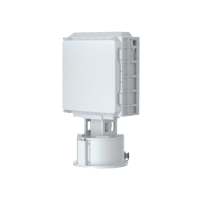
라진 테크놀로지, 우리는 안티 드론 장비에 중점을 두고 있습니다 개발 생산, 저고도 공역을 더욱 안전하게 만들기.

이메일: 마케팅@hzragine.com |

감지 시리즈/

저고도 감지 레이더

Detection unit performance parameters

Frequency band: X band

Detection range: 4 km (drone, RCS < 0.01 m ²)

Blind spot: 100 m

Angular coverage: Azimuth: 0 °~ 360 °, Pitch: 0~ 30

Tracking function: Equipped with tracking and TAS functions

Velocity range: 1 m/s~100 m/s

Accuracy: Distance: < 10 m, azimuth/pitch: < 0.6 ° (scan), azimuth/pitch: < 0.4 ° (길)

Target update rate: Not more than 3 s (configurable)


Machine performance parameters

Interface: Ethernet port

Weight: ≤28 kg

Power supply: AC 220 V

Power consumption: ≤400 W

Operating temperature range: Working temperature: -40 ℃~ + 55

Size:

  • Front size: 300 mm * 300 mm * 130 mm (excluding turntable)
  • Equipment size: 536 mm * 300 mm * 230 mm (including turntable)


Note: Variations may occur depending on operational environments and drone models. Certain specifications on this page are subject to change.

  • Product Details
  • Feature

Professional Low-Altitude Surveillance Solution for Critical Airspace Protection

The 저고도 감지 레이더 is a professional-grade surveillance system specifically engineered for monitoring low-altitude aerial targets such as unmanned aerial vehicles (UAVs). Designed to address the increasing security challenges posed by unauthorized drones, the system delivers reliable, all-weather detection, tracking, and threat assessment across complex operational environments.

Optimized for critical infrastructure protection, the radar is ideally suited for deployment in 공항, border areas, 에너지 시설, and other key sites where continuous low-altitude awareness, rapid response, and seamless system integration are essential.

X-Band Detection Technology with Three-Dimensional Coverage

Utilizing advanced X-band detection technology, the system achieves a detection range exceeding 4 킬로미터, with blind-spot coverage down to 100 meters, forming a comprehensive low-altitude monitoring network.

The radar integrates 360-degree horizontal scanning with up to 30 degrees of elevation coverage, enabling three-dimensional detection and accurate tracking of high-speed, low-speed, and hovering targets. This capability ensures stable performance in dense airspace environments and reliable detection of small, low-RCS drone targets.

Real-Time Tracking and Threat Assessment with Rapid Response

The Low-Altitude Detection Radar supports real-time target tracking and threat level assessment, providing continuous updates on target position, speed, trajectory, and behavior. A wide speed measurement range combined with second-level data refresh ensures precise capture of complex flight patterns.

With a response time of less than 3 seconds, security operators can rapidly identify potential threats and initiate appropriate countermeasures, significantly reducing response latency and improving overall airspace control efficiency.

Deployment Efficiency and Seamless System Integration

Designed with deployment practicality in mind, the system features a lightweight structure and supports a standard AC220V power supply, minimizing installation complexity and infrastructure requirements.

A standardized network interface enables seamless integration with existing security command and control platforms, supporting plug-and-play deployment within multi-layered security architectures. This integration capability reduces system commissioning time and lowers long-term operation and maintenance costs.

Industrial-Grade Reliability for Harsh Environments

Engineered for continuous operation, the radar maintains stable performance across a wide temperature range from –40°C to +55°C, making it suitable for harsh and remote environments.

The robust system design ensures 24/7 uninterrupted operation, meeting the reliability demands of mission-critical security applications and supporting long-term, large-scale deployments.

Typical Application Scenarios

  • Airport low-altitude airspace surveillance

  • Border and perimeter security

  • Protection of energy facilities and critical infrastructure

  • Integrated low-altitude security command systems

이전:

다음:

답장을 남겨주세요

이 사이트는 스팸을 줄이기 위해 Akismet을 사용합니다.. 댓글 데이터가 처리되는 방법 알아보기.

메시지를 남겨주세요